[{"cd_nom": 117156, "first_year": 2019.0, "geojson_maille": {"coordinates": [[[[1.87938346, 48.996685783], [1.87977119, 48.978703348], [1.852452337, 48.978445103], [1.852055154, 48.996427453], [1.87938346, 48.996685783]]]], "type": "MultiPolygon"}, "last_year": 2019.0, "observation_number": 1, "scientific_name": "Ranunculus parviflorus"}, {"cd_nom": 117156, "first_year": 2024.0, "geojson_maille": {"coordinates": [[[[2.001486927, 48.332106152], [2.001828052, 48.314113338], [1.974853423, 48.313882803], [1.974503082, 48.33187554], [2.001486927, 48.332106152]]]], "type": "MultiPolygon"}, "last_year": 2024.0, "observation_number": 1, "scientific_name": "Ranunculus parviflorus"}, {"cd_nom": 117156, "first_year": 2022.0, "geojson_maille": {"coordinates": [[[[2.016028884, 48.997884073], [2.016369346, 48.979901243], [1.989049218, 48.979674108], [1.988699302, 48.997656862], [2.016028884, 48.997884073]]]], "type": "MultiPolygon"}, "last_year": 2022.0, "observation_number": 1, "scientific_name": "Ranunculus parviflorus"}, {"cd_nom": 117156, "first_year": 2019.0, "geojson_maille": {"coordinates": [[[[2.016709573, 48.961918109], [2.017049564, 48.943934672], [1.989748325, 48.943707686], [1.989398892, 48.961691048], [2.016709573, 48.961918109]]]], "type": "MultiPolygon"}, "last_year": 2024.0, "observation_number": 3, "scientific_name": "Ranunculus parviflorus"}, {"cd_nom": 117156, "first_year": 2017.0, "geojson_maille": {"coordinates": [[[[2.017049564, 48.943934672], [2.01738932, 48.925950933], [1.990097515, 48.925724022], [1.989748325, 48.943707686], [2.017049564, 48.943934672]]]], "type": "MultiPolygon"}, "last_year": 2019.0, "observation_number": 7, "scientific_name": "Ranunculus parviflorus"}, {"cd_nom": 117156, "first_year": 2021.0, "geojson_maille": {"coordinates": [[[[2.044020489, 48.96213895], [2.044351039, 48.94415544], [2.017049564, 48.943934672], [2.016709573, 48.961918109], [2.044020489, 48.96213895]]]], "type": "MultiPolygon"}, "last_year": 2023.0, "observation_number": 2, "scientific_name": "Ranunculus parviflorus"}, {"cd_nom": 117156, "first_year": 2017.0, "geojson_maille": {"coordinates": [[[[2.044351039, 48.94415544], [2.04468136, 48.926171629], [2.01738932, 48.925950933], [2.017049564, 48.943934672], [2.044351039, 48.94415544]]]], "type": "MultiPolygon"}, "last_year": 2017.0, "observation_number": 1, "scientific_name": "Ranunculus parviflorus"}, {"cd_nom": 117156, "first_year": 2024.0, "geojson_maille": {"coordinates": [[[[2.187045979, 48.549448566], [2.187324864, 48.531458264], [2.160237703, 48.531270016], [2.159949523, 48.549260255], [2.187045979, 48.549448566]]]], "type": "MultiPolygon"}, "last_year": 2024.0, "observation_number": 1, "scientific_name": "Ranunculus parviflorus"}, {"cd_nom": 117156, "first_year": 2021.0, "geojson_maille": {"coordinates": [[[[2.208711682, 48.909380762], [2.208985011, 48.891395961], [2.181710553, 48.891212683], [2.1814278, 48.909197423], [2.208711682, 48.909380762]]]], "type": "MultiPolygon"}, "last_year": 2021.0, "observation_number": 1, "scientific_name": "Ranunculus parviflorus"}, {"cd_nom": 117156, "first_year": 2022.0, "geojson_maille": {"coordinates": [[[[2.235995753, 48.909557886], [2.236259659, 48.891573027], [2.208985011, 48.891395961], [2.208711682, 48.909380762], [2.235995753, 48.909557886]]]], "type": "MultiPolygon"}, "last_year": 2022.0, "observation_number": 1, "scientific_name": "Ranunculus parviflorus"}, {"cd_nom": 117156, "first_year": 2024.0, "geojson_maille": {"coordinates": [[[[2.259955658, 49.143504966], [2.260212442, 49.12552406], [2.232814596, 49.125352474], [2.232548304, 49.143333324], [2.259955658, 49.143504966]]]], "type": "MultiPolygon"}, "last_year": 2024.0, "observation_number": 1, "scientific_name": "Ranunculus parviflorus"}, {"cd_nom": 117156, "first_year": 2023.0, "geojson_maille": {"coordinates": [[[[2.265816943, 48.729866572], [2.266069677, 48.711878785], [2.238888726, 48.711708492], [2.238626634, 48.729696223], [2.265816943, 48.729866572]]]], "type": "MultiPolygon"}, "last_year": 2023.0, "observation_number": 1, "scientific_name": "Ranunculus parviflorus"}, {"cd_nom": 117156, "first_year": 2024.0, "geojson_maille": {"coordinates": [[[[2.268587471, 48.53198598], [2.268838301, 48.513995246], [2.241759873, 48.513825568], [2.241499755, 48.531816246], [2.268587471, 48.53198598]]]], "type": "MultiPolygon"}, "last_year": 2024.0, "observation_number": 1, "scientific_name": "Ranunculus parviflorus"}, {"cd_nom": 117156, "first_year": 2024.0, "geojson_maille": {"coordinates": [[[[2.287115745, 49.161651008], [2.287363191, 49.143670368], [2.259955658, 49.143504966], [2.259698696, 49.161485552], [2.287115745, 49.161651008]]]], "type": "MultiPolygon"}, "last_year": 2024.0, "observation_number": 1, "scientific_name": "Ranunculus parviflorus"}, {"cd_nom": 117156, "first_year": 2024.0, "geojson_maille": {"coordinates": [[[[2.287363191, 49.143670368], [2.287610466, 49.125689407], [2.260212442, 49.12552406], [2.259955658, 49.143504966], [2.287363191, 49.143670368]]]], "type": "MultiPolygon"}, "last_year": 2024.0, "observation_number": 1, "scientific_name": "Ranunculus parviflorus"}, {"cd_nom": 117156, "first_year": 2019.0, "geojson_maille": {"coordinates": [[[[2.291054383, 48.873923258], [2.291299104, 48.8559377], [2.264042926, 48.855773167], [2.263788795, 48.873758671], [2.291054383, 48.873923258]]]], "type": "MultiPolygon"}, "last_year": 2019.0, "observation_number": 2, "scientific_name": "Ranunculus parviflorus"}, {"cd_nom": 117156, "first_year": 2000.0, "geojson_maille": {"coordinates": [[[[2.291543655, 48.83795185], [2.291788038, 48.81996571], [2.264550662, 48.819801285], [2.264296882, 48.837787371], [2.291543655, 48.83795185]]]], "type": "MultiPolygon"}, "last_year": 2003.0, "observation_number": 2, "scientific_name": "Ranunculus parviflorus"}, {"cd_nom": 117156, "first_year": 2022.0, "geojson_maille": {"coordinates": [[[[2.292032252, 48.801979282], [2.292276298, 48.783992568], [2.265057699, 48.783828251], [2.264804268, 48.801814911], [2.292032252, 48.801979282]]]], "type": "MultiPolygon"}, "last_year": 2022.0, "observation_number": 3, "scientific_name": "Ranunculus parviflorus"}, {"cd_nom": 117156, "first_year": 2022.0, "geojson_maille": {"coordinates": [[[[2.294707535, 48.604110087], [2.294949741, 48.586120345], [2.267833948, 48.585956622], [2.267582429, 48.603946309], [2.294707535, 48.604110087]]]], "type": "MultiPolygon"}, "last_year": 2022.0, "observation_number": 1, "scientific_name": "Ranunculus parviflorus"}, {"cd_nom": 117156, "first_year": 2023.0, "geojson_maille": {"coordinates": [[[[2.29567536, 48.532149542], [2.295916901, 48.514158754], [2.268838301, 48.513995246], [2.268587471, 48.53198598], [2.29567536, 48.532149542]]]], "type": "MultiPolygon"}, "last_year": 2024.0, "observation_number": 3, "scientific_name": "Ranunculus parviflorus"}, {"cd_nom": 117156, "first_year": 2018.0, "geojson_maille": {"coordinates": [[[[2.319025582, 48.820123931], [2.319260405, 48.802137451], [2.292032252, 48.801979282], [2.291788038, 48.81996571], [2.319025582, 48.820123931]]]], "type": "MultiPolygon"}, "last_year": 2024.0, "observation_number": 5, "scientific_name": "Ranunculus parviflorus"}, {"cd_nom": 117156, "first_year": 2019.0, "geojson_maille": {"coordinates": [[[[2.324847968, 48.370380283], [2.325078793, 48.352387197], [2.29808334, 48.352230323], [2.297843283, 48.370223357], [2.324847968, 48.370380283]]]], "type": "MultiPolygon"}, "last_year": 2019.0, "observation_number": 1, "scientific_name": "Ranunculus parviflorus"}, {"cd_nom": 117156, "first_year": 2019.0, "geojson_maille": {"coordinates": [[[[2.325078793, 48.352387197], [2.325309461, 48.334393871], [2.298323232, 48.334237048], [2.29808334, 48.352230323], [2.325078793, 48.352387197]]]], "type": "MultiPolygon"}, "last_year": 2019.0, "observation_number": 2, "scientific_name": "Ranunculus parviflorus"}, {"cd_nom": 117156, "first_year": 2019.0, "geojson_maille": {"coordinates": [[[[2.346037701, 48.838262189], [2.346263288, 48.820275947], [2.319025582, 48.820123931], [2.318790597, 48.838110123], [2.346037701, 48.838262189]]]], "type": "MultiPolygon"}, "last_year": 2024.0, "observation_number": 4, "scientific_name": "Ranunculus parviflorus"}, {"cd_nom": 117156, "first_year": 2023.0, "geojson_maille": {"coordinates": [[[[2.346713995, 48.784302601], [2.346939116, 48.7663155], [2.319729565, 48.766163634], [2.319495066, 48.784150685], [2.346713995, 48.784302601]]]], "type": "MultiPolygon"}, "last_year": 2023.0, "observation_number": 1, "scientific_name": "Ranunculus parviflorus"}, {"cd_nom": 117156, "first_year": 2024.0, "geojson_maille": {"coordinates": [[[[2.372418713, 48.910350291], [2.372635499, 48.892365172], [2.345360006, 48.892219168], [2.345133795, 48.910204239], [2.372418713, 48.910350291]]]], "type": "MultiPolygon"}, "last_year": 2024.0, "observation_number": 1, "scientific_name": "Ranunculus parviflorus"}, {"cd_nom": 117156, "first_year": 2023.0, "geojson_maille": {"coordinates": [[[[2.372852136, 48.874379757], [2.373068623, 48.856394049], [2.345811959, 48.856248141], [2.34558606, 48.874233801], [2.372852136, 48.874379757]]]], "type": "MultiPolygon"}, "last_year": 2023.0, "observation_number": 2, "scientific_name": "Ranunculus parviflorus"}, {"cd_nom": 117156, "first_year": 2022.0, "geojson_maille": {"coordinates": [[[[2.373284961, 48.838408049], [2.37350115, 48.820421759], [2.346263288, 48.820275947], [2.346037701, 48.838262189], [2.373284961, 48.838408049]]]], "type": "MultiPolygon"}, "last_year": 2022.0, "observation_number": 1, "scientific_name": "Ranunculus parviflorus"}, {"cd_nom": 117156, "first_year": 2022.0, "geojson_maille": {"coordinates": [[[[2.37350115, 48.820421759], [2.373717189, 48.802435181], [2.346488719, 48.802289417], [2.346263288, 48.820275947], [2.37350115, 48.820421759]]]], "type": "MultiPolygon"}, "last_year": 2024.0, "observation_number": 5, "scientific_name": "Ranunculus parviflorus"}, {"cd_nom": 117156, "first_year": 2023.0, "geojson_maille": {"coordinates": [[[[2.37393308, 48.784448317], [2.374148821, 48.766461169], [2.346939116, 48.7663155], [2.346713995, 48.784302601], [2.37393308, 48.784448317]]]], "type": "MultiPolygon"}, "last_year": 2023.0, "observation_number": 1, "scientific_name": "Ranunculus parviflorus"}, {"cd_nom": 117156, "first_year": 2022.0, "geojson_maille": {"coordinates": [[[[2.374148821, 48.766461169], [2.374364415, 48.748473738], [2.347164081, 48.748328117], [2.346939116, 48.7663155], [2.374148821, 48.766461169]]]], "type": "MultiPolygon"}, "last_year": 2024.0, "observation_number": 6, "scientific_name": "Ranunculus parviflorus"}, {"cd_nom": 117156, "first_year": 2021.0, "geojson_maille": {"coordinates": [[[[2.374579859, 48.730486026], [2.374795156, 48.712498035], [2.347613547, 48.712352511], [2.347388892, 48.730340454], [2.374579859, 48.730486026]]]], "type": "MultiPolygon"}, "last_year": 2021.0, "observation_number": 1, "scientific_name": "Ranunculus parviflorus"}, {"cd_nom": 117156, "first_year": 2021.0, "geojson_maille": {"coordinates": [[[[2.374795156, 48.712498035], [2.375010304, 48.694509768], [2.347838049, 48.694364291], [2.347613547, 48.712352511], [2.374795156, 48.712498035]]]], "type": "MultiPolygon"}, "last_year": 2021.0, "observation_number": 1, "scientific_name": "Ranunculus parviflorus"}, {"cd_nom": 117156, "first_year": 2021.0, "geojson_maille": {"coordinates": [[[[2.399080833, 48.964443835], [2.399288626, 48.946459566], [2.37198469, 48.946319637], [2.371767453, 48.964303859], [2.399080833, 48.964443835]]]], "type": "MultiPolygon"}, "last_year": 2024.0, "observation_number": 3, "scientific_name": "Ranunculus parviflorus"}, {"cd_nom": 117156, "first_year": 2005.0, "geojson_maille": {"coordinates": [[[[2.400118362, 48.874519503], [2.400325437, 48.856533748], [2.373068623, 48.856394049], [2.372852136, 48.874379757], [2.400118362, 48.874519503]]]], "type": "MultiPolygon"}, "last_year": 2024.0, "observation_number": 5, "scientific_name": "Ranunculus parviflorus"}, {"cd_nom": 117156, "first_year": 2022.0, "geojson_maille": {"coordinates": [[[[2.40053237, 48.838547702], [2.400739161, 48.820561367], [2.37350115, 48.820421759], [2.373284961, 48.838408049], [2.40053237, 48.838547702]]]], "type": "MultiPolygon"}, "last_year": 2022.0, "observation_number": 1, "scientific_name": "Ranunculus parviflorus"}, {"cd_nom": 117156, "first_year": 2023.0, "geojson_maille": {"coordinates": [[[[2.401152313, 48.784587833], [2.401358676, 48.766600638], [2.374148821, 48.766461169], [2.37393308, 48.784448317], [2.401152313, 48.784587833]]]], "type": "MultiPolygon"}, "last_year": 2023.0, "observation_number": 1, "scientific_name": "Ranunculus parviflorus"}, {"cd_nom": 117156, "first_year": 2023.0, "geojson_maille": {"coordinates": [[[[2.401358676, 48.766600638], [2.401564897, 48.748613162], [2.374364415, 48.748473738], [2.374148821, 48.766461169], [2.401358676, 48.766600638]]]], "type": "MultiPolygon"}, "last_year": 2023.0, "observation_number": 1, "scientific_name": "Ranunculus parviflorus"}, {"cd_nom": 117156, "first_year": 2022.0, "geojson_maille": {"coordinates": [[[[2.401564897, 48.748613162], [2.401770975, 48.730625404], [2.374579859, 48.730486026], [2.374364415, 48.748473738], [2.401564897, 48.748613162]]]], "type": "MultiPolygon"}, "last_year": 2022.0, "observation_number": 5, "scientific_name": "Ranunculus parviflorus"}, {"cd_nom": 117156, "first_year": 2021.0, "geojson_maille": {"coordinates": [[[[2.401770975, 48.730625404], [2.401976912, 48.712637368], [2.374795156, 48.712498035], [2.374579859, 48.730486026], [2.401770975, 48.730625404]]]], "type": "MultiPolygon"}, "last_year": 2021.0, "observation_number": 1, "scientific_name": "Ranunculus parviflorus"}, {"cd_nom": 117156, "first_year": 2021.0, "geojson_maille": {"coordinates": [[[[2.401976912, 48.712637368], [2.402182707, 48.694649054], [2.375010304, 48.694509768], [2.374795156, 48.712498035], [2.401976912, 48.712637368]]]], "type": "MultiPolygon"}, "last_year": 2021.0, "observation_number": 1, "scientific_name": "Ranunculus parviflorus"}, {"cd_nom": 117156, "first_year": 2021.0, "geojson_maille": {"coordinates": [[[[2.402182707, 48.694649054], [2.40238836, 48.676660466], [2.375225304, 48.676521225], [2.375010304, 48.694509768], [2.402182707, 48.694649054]]]], "type": "MultiPolygon"}, "last_year": 2021.0, "observation_number": 1, "scientific_name": "Ranunculus parviflorus"}, {"cd_nom": 117156, "first_year": 2019.0, "geojson_maille": {"coordinates": [[[[2.403823982, 48.550732796], [2.404028507, 48.532742073], [2.376939994, 48.532603198], [2.376726173, 48.550593876], [2.403823982, 48.550732796]]]], "type": "MultiPolygon"}, "last_year": 2019.0, "observation_number": 3, "scientific_name": "Ranunculus parviflorus"}, {"cd_nom": 117156, "first_year": 2023.0, "geojson_maille": {"coordinates": [[[[2.404028507, 48.532742073], [2.404232893, 48.51475109], [2.377153669, 48.514612261], [2.376939994, 48.532603198], [2.404028507, 48.532742073]]]], "type": "MultiPolygon"}, "last_year": 2023.0, "observation_number": 4, "scientific_name": "Ranunculus parviflorus"}, {"cd_nom": 117156, "first_year": 2021.0, "geojson_maille": {"coordinates": [[[[2.426394357, 48.964577589], [2.426592706, 48.946593277], [2.399288626, 48.946459566], [2.399080833, 48.964443835], [2.426394357, 48.964577589]]]], "type": "MultiPolygon"}, "last_year": 2024.0, "observation_number": 13, "scientific_name": "Ranunculus parviflorus"}, {"cd_nom": 117156, "first_year": 2021.0, "geojson_maille": {"coordinates": [[[[2.426592706, 48.946593277], [2.426790917, 48.928608664], [2.399496275, 48.928474997], [2.399288626, 48.946459566], [2.426592706, 48.946593277]]]], "type": "MultiPolygon"}, "last_year": 2024.0, "observation_number": 20, "scientific_name": "Ranunculus parviflorus"}, {"cd_nom": 117156, "first_year": 2022.0, "geojson_maille": {"coordinates": [[[[2.427977314, 48.82069477], [2.428174569, 48.802708102], [2.400945808, 48.802574743], [2.400739161, 48.820561367], [2.427977314, 48.82069477]]]], "type": "MultiPolygon"}, "last_year": 2022.0, "observation_number": 1, "scientific_name": "Ranunculus parviflorus"}, {"cd_nom": 117156, "first_year": 2023.0, "geojson_maille": {"coordinates": [[[[2.428371689, 48.784721148], [2.428568673, 48.76673391], [2.401358676, 48.766600638], [2.401152313, 48.784587833], [2.428371689, 48.784721148]]]], "type": "MultiPolygon"}, "last_year": 2023.0, "observation_number": 7, "scientific_name": "Ranunculus parviflorus"}, {"cd_nom": 117156, "first_year": 2022.0, "geojson_maille": {"coordinates": [[[[2.428765521, 48.748746389], [2.428962233, 48.730758588], [2.401770975, 48.730625404], [2.401564897, 48.748613162], [2.428765521, 48.748746389]]]], "type": "MultiPolygon"}, "last_year": 2022.0, "observation_number": 6, "scientific_name": "Ranunculus parviflorus"}, {"cd_nom": 117156, "first_year": 2021.0, "geojson_maille": {"coordinates": [[[[2.428962233, 48.730758588], [2.42915881, 48.712770508], [2.401976912, 48.712637368], [2.401770975, 48.730625404], [2.428962233, 48.730758588]]]], "type": "MultiPolygon"}, "last_year": 2021.0, "observation_number": 1, "scientific_name": "Ranunculus parviflorus"}, {"cd_nom": 117156, "first_year": 2021.0, "geojson_maille": {"coordinates": [[[[2.42915881, 48.712770508], [2.429355251, 48.694782151], [2.402182707, 48.694649054], [2.401976912, 48.712637368], [2.42915881, 48.712770508]]]], "type": "MultiPolygon"}, "last_year": 2021.0, "observation_number": 1, "scientific_name": "Ranunculus parviflorus"}, {"cd_nom": 117156, "first_year": 2023.0, "geojson_maille": {"coordinates": [[[[2.455027611, 48.83880839], [2.455215603, 48.820821968], [2.427977314, 48.82069477], [2.427779922, 48.838681149], [2.455027611, 48.83880839]]]], "type": "MultiPolygon"}, "last_year": 2023.0, "observation_number": 1, "scientific_name": "Ranunculus parviflorus"}, {"cd_nom": 117156, "first_year": 2023.0, "geojson_maille": {"coordinates": [[[[2.455215603, 48.820821968], [2.455403467, 48.802835259], [2.428174569, 48.802708102], [2.427977314, 48.82069477], [2.455215603, 48.820821968]]]], "type": "MultiPolygon"}, "last_year": 2023.0, "observation_number": 1, "scientific_name": "Ranunculus parviflorus"}, {"cd_nom": 117156, "first_year": 2017.0, "geojson_maille": {"coordinates": [[[[2.457088424, 48.640942217], [2.457274998, 48.622952729], [2.430139668, 48.622825989], [2.429943766, 48.640815436], [2.457088424, 48.640942217]]]], "type": "MultiPolygon"}, "last_year": 2017.0, "observation_number": 1, "scientific_name": "Ranunculus parviflorus"}, {"cd_nom": 117156, "first_year": 2023.0, "geojson_maille": {"coordinates": [[[[2.482275429, 48.838929424], [2.482454023, 48.820942962], [2.455215603, 48.820821968], [2.455027611, 48.83880839], [2.482275429, 48.838929424]]]], "type": "MultiPolygon"}, "last_year": 2023.0, "observation_number": 1, "scientific_name": "Ranunculus parviflorus"}, {"cd_nom": 117156, "first_year": 2024.0, "geojson_maille": {"coordinates": [[[[2.508165593, 48.982925658], [2.508335726, 48.964941528], [2.48102181, 48.964826436], [2.480842226, 48.982810528], [2.508165593, 48.982925658]]]], "type": "MultiPolygon"}, "last_year": 2024.0, "observation_number": 1, "scientific_name": "Ranunculus parviflorus"}, {"cd_nom": 117156, "first_year": 2022.0, "geojson_maille": {"coordinates": [[[[2.508335726, 48.964941528], [2.508505741, 48.946957096], [2.48120127, 48.946842042], [2.48102181, 48.964826436], [2.508335726, 48.964941528]]]], "type": "MultiPolygon"}, "last_year": 2022.0, "observation_number": 1, "scientific_name": "Ranunculus parviflorus"}, {"cd_nom": 117156, "first_year": 2020.0, "geojson_maille": {"coordinates": [[[[2.536451505, 48.87512507], [2.536611521, 48.857139117], [2.509354058, 48.85703046], [2.509184629, 48.875016378], [2.536451505, 48.87512507]]]], "type": "MultiPolygon"}, "last_year": 2020.0, "observation_number": 4, "scientific_name": "Ranunculus parviflorus"}, {"cd_nom": 117156, "first_year": 2020.0, "geojson_maille": {"coordinates": [[[[2.536611521, 48.857139117], [2.536771428, 48.839152872], [2.50952337, 48.839044251], [2.509354058, 48.85703046], [2.536611521, 48.857139117]]]], "type": "MultiPolygon"}, "last_year": 2020.0, "observation_number": 1, "scientific_name": "Ranunculus parviflorus"}, {"cd_nom": 117156, "first_year": 2020.0, "geojson_maille": {"coordinates": [[[[2.53788769, 48.713241145], [2.538046717, 48.695252634], [2.510873671, 48.695144298], [2.51070529, 48.713132775], [2.53788769, 48.713241145]]]], "type": "MultiPolygon"}, "last_year": 2020.0, "observation_number": 1, "scientific_name": "Ranunculus parviflorus"}, {"cd_nom": 117156, "first_year": 2023.0, "geojson_maille": {"coordinates": [[[[2.563266052, 48.929183745], [2.563416969, 48.911198644], [2.536131139, 48.911096095], [2.53597079, 48.929081163], [2.563266052, 48.929183745]]]], "type": "MultiPolygon"}, "last_year": 2023.0, "observation_number": 6, "scientific_name": "Ranunculus parviflorus"}, {"cd_nom": 117156, "first_year": 2021.0, "geojson_maille": {"coordinates": [[[[2.563718491, 48.875227552], [2.563869096, 48.857241564], [2.536611521, 48.857139117], [2.536451505, 48.87512507], [2.563718491, 48.875227552]]]], "type": "MultiPolygon"}, "last_year": 2024.0, "observation_number": 3, "scientific_name": "Ranunculus parviflorus"}, {"cd_nom": 117156, "first_year": 2021.0, "geojson_maille": {"coordinates": [[[[2.593651672, 48.533541382], [2.59379103, 48.515550137], [2.566710958, 48.515454498], [2.56656231, 48.533445711], [2.593651672, 48.533541382]]]], "type": "MultiPolygon"}, "last_year": 2021.0, "observation_number": 1, "scientific_name": "Ranunculus parviflorus"}, {"cd_nom": 117156, "first_year": 2018.0, "geojson_maille": {"coordinates": [[[[2.622037806, 48.353706802], [2.622166987, 48.335713043], [2.595179371, 48.335623867], [2.595040964, 48.353617597], [2.622037806, 48.353706802]]]], "type": "MultiPolygon"}, "last_year": 2018.0, "observation_number": 1, "scientific_name": "Ranunculus parviflorus"}, {"cd_nom": 117156, "first_year": 2023.0, "geojson_maille": {"coordinates": [[[[2.645520048, 48.875497731], [2.645642416, 48.857511655], [2.618384549, 48.857427833], [2.618252769, 48.875413882], [2.645520048, 48.875497731]]]], "type": "MultiPolygon"}, "last_year": 2024.0, "observation_number": 2, "scientific_name": "Ranunculus parviflorus"}, {"cd_nom": 117156, "first_year": 2016.0, "geojson_maille": {"coordinates": [[[[2.646739934, 48.69562407], [2.646861461, 48.677635161], [2.619697363, 48.677551615], [2.619566488, 48.695540497], [2.646739934, 48.69562407]]]], "type": "MultiPolygon"}, "last_year": 2016.0, "observation_number": 1, "scientific_name": "Ranunculus parviflorus"}, {"cd_nom": 117156, "first_year": 2023.0, "geojson_maille": {"coordinates": [[[[2.672787411, 48.875575369], [2.672900366, 48.857589267], [2.645642416, 48.857511655], [2.645520048, 48.875497731], [2.672787411, 48.875575369]]]], "type": "MultiPolygon"}, "last_year": 2024.0, "observation_number": 3, "scientific_name": "Ranunculus parviflorus"}, {"cd_nom": 117156, "first_year": 2023.0, "geojson_maille": {"coordinates": [[[[2.757355057, 48.282083621], [2.757437876, 48.264088803], [2.730486728, 48.264030454], [2.730394707, 48.282025253], [2.757355057, 48.282083621]]]], "type": "MultiPolygon"}, "last_year": 2023.0, "observation_number": 1, "scientific_name": "Ranunculus parviflorus"}, {"cd_nom": 117156, "first_year": 2024.0, "geojson_maille": {"coordinates": [[[[2.972684966, 48.965946261], [2.972694412, 48.947961499], [2.94538883, 48.94795217], [2.945369939, 48.965936929], [2.972684966, 48.965946261]]]], "type": "MultiPolygon"}, "last_year": 2024.0, "observation_number": 1, "scientific_name": "Ranunculus parviflorus"}, {"cd_nom": 117156, "first_year": 2016.0, "geojson_maille": {"coordinates": [[[[3.433289042, 48.515454498], [3.433140496, 48.497463027], [3.406069708, 48.497558635], [3.40620897, 48.515550137], [3.433289042, 48.515454498]]]], "type": "MultiPolygon"}, "last_year": 2019.0, "observation_number": 3, "scientific_name": "Ranunculus parviflorus"}]
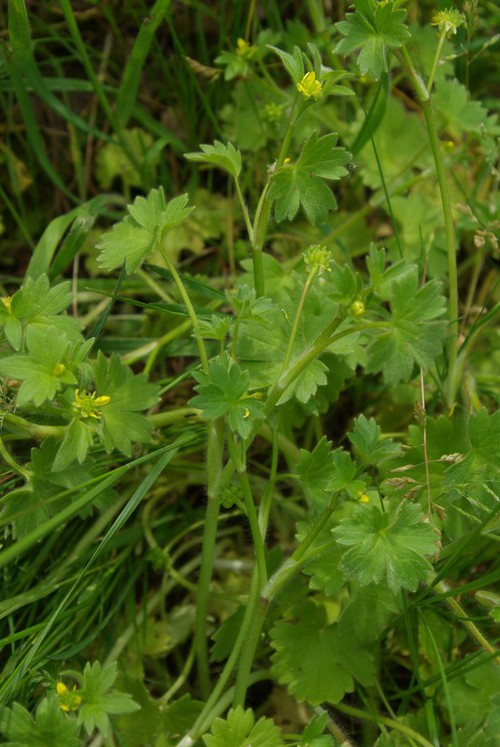
Avertissement : La carte présentée ne correspond qu'à l'état actuel des connaissances
et ne peut être considérée comme exhaustive. Cette carte est une retranscription en temps réel des
contributions de chacun sur la base de données et toute nouvelle donnée est à ce titre intéressante,
même pour les espèces les plus communes.